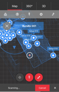
Our 3D Laser Scanning equipment captures existing site data to incredible detail so all your plans are accurate and up to date.
The scanner captures;
Building Structure
Floor levels
Services
Equipment
HVAC
Refrigeration
The entire site is captured in precise detail
A 3D Laser scan can be used for number of different projects;
Documentation of historical sites
Site modeling and layout
Quality control
Quantity surveys
Roadway mapping and re-design
Building information modeling (BIM)
Establishing a bench mark of pre-existing shape/state in order to detect structural changes
‘If the scanner can see it it will be measured to an accuracy of +-2mm’
The advantages of 3D laser scanning are;
With a 3D scan the entire site is captured in precise detail exactly as it can be seen in the real world with your eyes
The scan can be uploaded to a web portal and it can be viewed through any web browser
All of the scan locations can be clicked on to view them as an interactive 360 degree panoramic view (similar to Google street view)
All of the panoramic views are created with precise 3D scan data, with our web portal you get tools to measure whatever you can see!!
You can annotate the views for mark up and proposal purposes!
the scan data can be used to create accurate 3D Models for Visualisations or BIM
‘If you need to move your project into a BIM environment then a 3D laser scan of your existing site is the perfect start.

Contact us for more info...


